WATCH LIVE: Severe Weather Coverage
Significant damage has been reported in the town of Seminole Wednesday night after a tornado hit the heart of its downtown.
There have been no reports of injuries yet, but the extent of the damage was apparent from Jim Gardner in Bob Mills Sky News 9.
***
Most of the News 9 viewing area is in a tornado watch Wednesday afternoon and evening as another storm system moves through the state. Storms are moving NE across parts of the state, northwest of the Oklahoma City metro.
News 9 Chief Meteorologist David Payne says that the Oklahoma City metro could see severe weather later Wednesday afternoon or evening. In the meantime, we will keep you updated with live updates from the News 9 weather team and the National Weather Service.
**
UPDATE: Severe Thunderstorm Warning issued for Greer and Jackson County until 9:30 p.m.
UPDATE: Flash Flood Warning issued for Pottawatomie and Seminole County until 11:45 p.m.
UPDATE: Tornado Warning issued for Okfuskee County until 9:30 p.m.
UPDATE: Severe Thunderstorm Warning issued for Okfuskee County until 9:30 p.m.
UPDATE: Tornado Warning issued for Pottawatomie and Seminole County until 9:15 p.m.
UPDATE: Flash Flood Warning for Seminole County until 11:30 p.m.
UPDATE: Tornado Warning for Greer and Harmon County until 9:15 p.m.
UPDATE: Severe Thunderstorm Warning for Lincoln, Pottawatomie, and Seminole County until 9:15 p.m.
UPDATE: Tornado Warning issued for Pottawatomie and Seminole County until 8:45 p.m.
UPDATE: Flash Flood Warning issued for Okfuskee County until 11:45 p.m.
UPDATE: Severe Thunderstorm Warning issued for Cleveland, Pottawatomie, and Seminole County until 8:30 p.m.
UPDATE: Tornado Warning issued for Seminole County until 8:00 p.m.
UPDATE: Seminole is without power after a Tornado moved through the town before 7 p.m.
UPDATE: Severe Thunderstorm Warning for Okfuskee County until 7:45 p.m.
UPDATE: Tornado Warning for Cleveland and McClain County until 7:30pm.
UPDATE: Tornado Warning issued for Seminole County until 7:15 p.m.
UPDATE: Tornado Warning for Pottawatomie and Seminole County until 7:00 p.m.
UPDATE: A Severe Thunderstorm Warning has been issued for Pottawatomie County until 7 p.m.
UPDATE: A Severe Thunderstorm Warning has been issued for Cleveland and Pottawatomie County until 6:15 p.m.
UPDATE: A Severe Thunderstorm Warning has been issued for Kay County until 6:00 p.m.
UPDATE: Areal Flood Watch for Alfalfa, Kay, Major, Garfield, Noble, Blaine, Kingfisher, Logan, Payne, Caddo, Canadian, Oklahoma, Lincoln, Grady, McClain, Cleveland, Pottawatomie, Seminole, Hughes, Tillman, Comanche, Stephens, Garvin, Murray, Pontotoc, Jefferson, Carter and Love County until 7:00 a.m Thursday.
UPDATE: A Severe Thunderstorm Warning has been issued for Garfield County until 4:45 p.m.
UPDATE: A Severe Thunderstorm Warning has been issued for Blaine, Garfield, Kingfisher and Major counties until 4 p.m.
UPDATE: A Severe Thunderstorm Warning has been issued for Garfield, Kingfisher, Logan, Noble and Payne counties until 3:45 p.m.
UPDATE: A Severe Thunderstorm Warning has been issued for Blaine, Garfield, Kingfisher and Major counties until 3:15 p.m.
UPDATE: A Severe Thunderstorm Warning has been issued for Alfalfa, Blaine, Garfield and Major counties until 2:45 p.m.
UPDATE: A Severe Thunderstorm Warning has been issued for Blaine and Kingfisher County until 2:45 p.m.
UPDATE: A Tornado Watch has been issued for Beckham, Custer, Dewey, Greer, Harmon, Jackson, Roger Mills, Tillman and Washita County until 10 p.m.
UPDATE: A Tornado Watch has been issued for Blaine, Caddo, Canadian, Carter, Cleveland, Comanche, Garvin, Grady, Hughes, Jefferson, Kingfisher, Lincoln, Logan, Love, McClain, Murray, Okfuskee, Oklahoma, Payne, Pontotoc, Pottawatomie and Seminole County until 10 p.m.
Below is a detailed look at Wednesday afternoon and evening’s forecast.
————————————————————————-
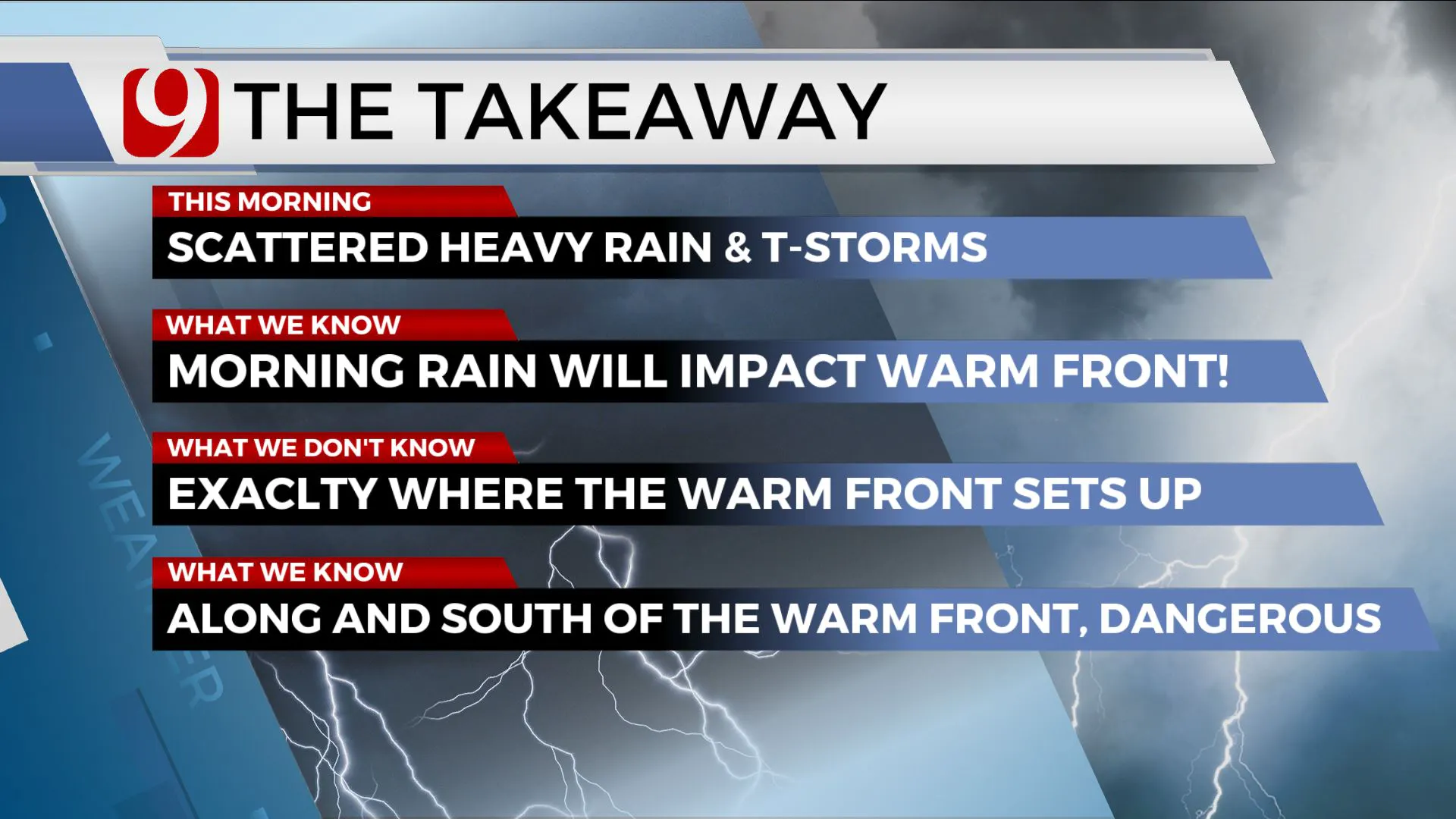
While we had some storms Wednesday morning, central Oklahoma will have the chance for high-end severe storms later in the day.
Wednesday morning’s rain will impact the location of the warm front later in the afternoon.
Why is that important? Because any location along or to the south of the warm front could see strong, severe storms.
It will be warm and unstable. North of the warm front, highs will be in the 50s with a very low severe threat.
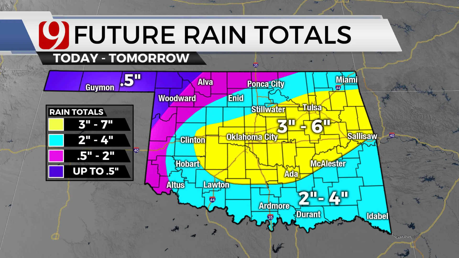
We are expecting several rounds of heavy rain and storms Wednesday and into the night.
Flooding rains are expected. Not everyone will see flooding, of course, but some areas could see three to six inches.
As the warm front surges northward, scattered showers and storms will develop in the northwest Wednesday afternoon. These could produce some hail and wind.
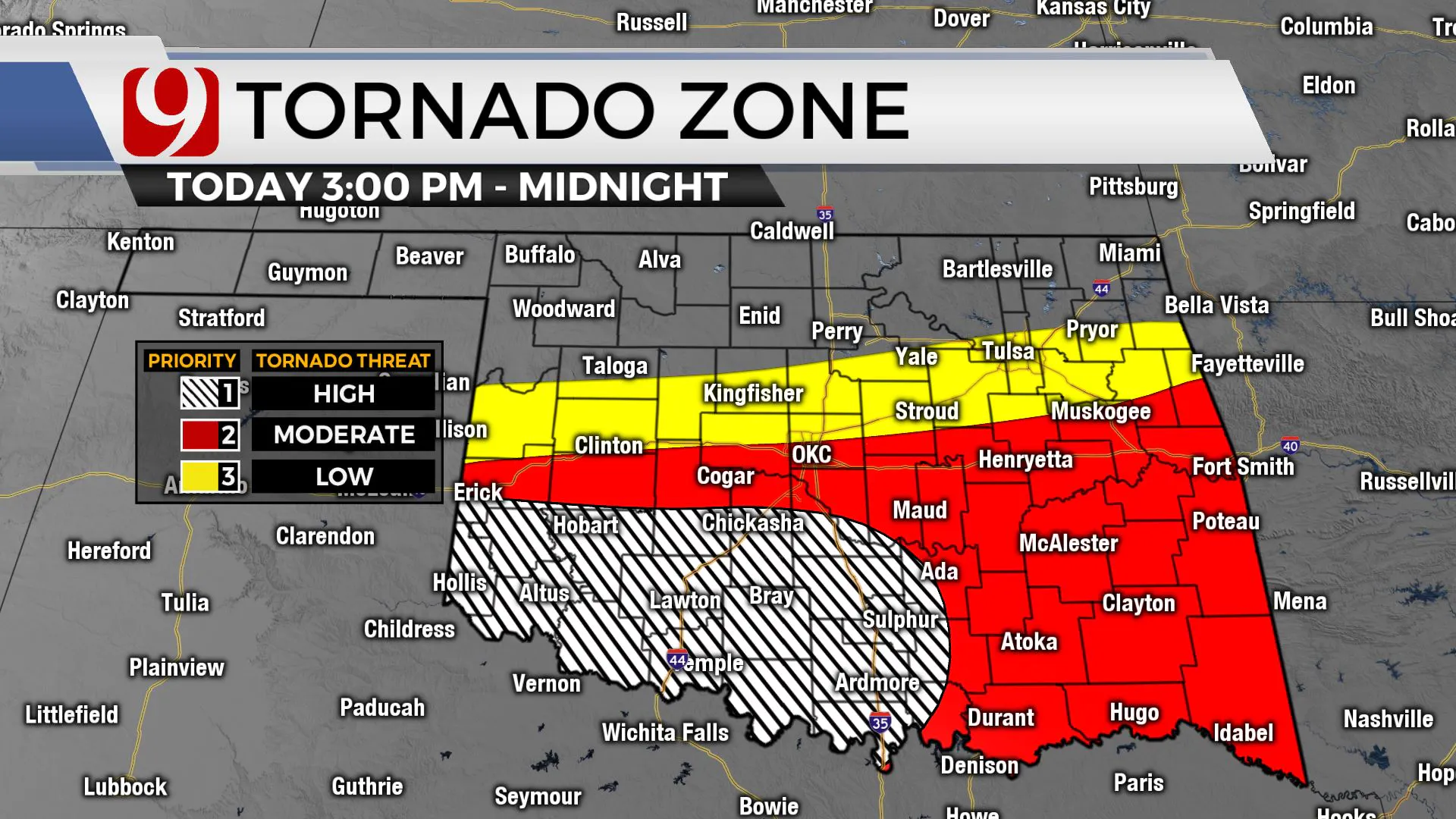
Farther south, isolated storm chances go up Wednesday afternoon and any storm that forms south of the boundary could produce very large hail, damaging winds and a tornado.
More widespread storms could develop and could still posing a risk for severe storms tonight.
As of now, the highest risk for very large hail and tornadoes is in southwest Oklahoma.
However, all areas south of the boundary need to pay close attention.
Our team of trackers will be out all day and night, and we will bring you updates.
A Flood Watch has been issued for the following counties in Oklahoma from 6 a.m. Wednesday until Thursday at 12 p.m.
Alfalfa, Atoka, Blaine, Bryan, Caddo, Canadian, Carter, Cleveland, Coal, Comanche, Cotton, Garfield, Garvin, Grady, Grant, Hughes, Jefferson, Johnston, Kay, Kingfisher, Lincoln, Logan, Love, Major, Marshall, McClain, Murray, Noble, Oklahoma, Payne, Pontotoc, Pottawatomie, Seminole, Stephens and Tillman counties.
George is Digismak’s reported cum editor with 13 years of experience in Journalism


