Snowflakes in the air Sunday, but more bark than bite
No weather worries ahead Saturday evening. More clouds will develop, but no rain or snow comes to Richmond before midnight. Temperatures will fall through the 50s during Saturday evening.
A dramatic temperature change is ahead for Sunday. While there will be occasional snowflakes in the air, a large accumulating snow is not expected Sunday or Sunday night in metro Richmond.
Spotty light rain showers will develop a couple of hours before dawn on Sunday as temperatures continue to drop to near the freezing mark, then a cold north breeze will keep temperatures from climbing at all during Sunday morning and afternoon.
The spotty light rain will transition to occasional light snow, with most of the snow falling during the late morning and early afternoon on Sunday. Most of the time the snow will be light, with a coating to an inch of accumulation by late Sunday afternoon. In general, accumulation will be on grassy and elevated surfaces, so only minor impacts to travel are expected.
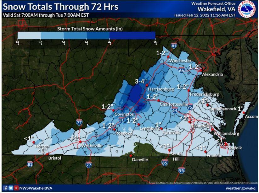
State forecast snow totals for Sunday. (NWS Wakefield)
More snow will fall in northern and western parts of Virginia on Sunday. Accumulations will be around 1-3 inches northward to Fredericksburg and westward toward Charlottesville, Staunton, and Lexington. An inch or two is also likely toward Lynchburg and Roanoke.
People are also reading…
A secondary disturbance will quickly cross Virginia late Sunday night, bringing a few more snow showers for an hour or so between midnight and dawn to metro Richmond, but no more than an additional dusting is expected on Sunday night.
All snow will end by daybreak Monday, but any surfaces that were wet on Sunday afternoon will be icy on Monday morning, as daybreak temperatures Monday will be in the lower 20s.
The fresh shot of Arctic air arriving on Sunday will not hold on to Virginia for more than a couple of days, as temperatures sneak above normal on Wednesday. Next week will also be dry through Wednesday, with no chance of rain until the next system pushes through Thursday and Thursday night. Once that clears on Friday, the weekend of the 19th and 20th looks dry and seasonable.
Saturday night: Spotty light rain developing after midnight. Low 34.
Sunday: Occasional light snow, mostly in the late morning and early afternoon. Accumulation up to an inch. Temperatures nearly steady in the lower to middle 30s.
Sunday night: Partly to mostly cloudy, with occasional snow showers after midnight, adding a dusting to a coating. Low 24.
Monday: Sun and clouds, cold. High 38.
Wednesday: Mostly sunny. High 58.
Thursday: Cloudy and mild with rain likely in the afternoon and continuing into the night. High 66.
Friday: Sun and clouds, breezy, and cooler. High 52.
Saturday: Sunny. High 50.
George is Digismak’s reported cum editor with 13 years of experience in Journalism